Source: Eyeidea / Getty
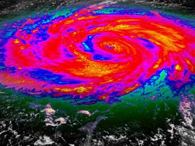
Thursday afternoon in the Atlantic Ocean hurricane Joaquin continued to strengthen, becoming an extremely dangerous Category 4 storm. Around 2 p.m. Thursday, Joaquin became a powerful Category 4 storm with maximum sustained winds of about 130 mph.
The storm is centered near the central Bahamas, which is about 922 miles south-southeast of Raleigh, and it is still drifting west-southwest at 6 mph. Gardner said “Bottom line, this storm is going to have a major impact on North Carolina even if it doesn’t make landfall along the Outer Banks.”
Joaquin has exploded within the last 24 hours, from a Category 1 storm with winds of about 80 mph to a major hurricane and its forecast track hasn’t been any less volatile. Gardner also had this to say about its location “One of the computer models that was pulling Joaquin directly into North Carolina has shifted it offshore a bit, so the National Hurricane Center has shifted its track.”
When it is along the Carolina during the day on Sunday, it is expected to be a Category 2 storm.”By Sunday and early Monday, as Joaquin is either making landfall along the Outer Banks or passing just offshore, we’re thinking it could have winds of 90 to 110 mph. Either way, it will have a big impact on the coast with heavy rain and wind” says Gardner.
A state of emergency was declared by officials in Hyde County and residents as well as visitors were ordered to evacuate Ocracoke Island. Beginning Saturday no inbound traffic will be allowed.
After moving past North Carolina, Joaquin is expected to continue to weaken and move up the East Coast. Much of central and eastern North Carolina is expected to see several inches of rain as a cold front combines with an area of low pressure on Thursday, Friday and Saturday.
The National Weather Service has issued flash flood watches for the entire area from 8 p.m. Thursday through 8 p.m. Sunday, warning of flooding in low-lying, flood-prone areas. State Emergency Management officials said fallen trees and power lines could also be an issue as well.
For more information click here
Text “LIGHT” To 37890 for your chance at ticket giveaways and news before anyone else!…Standard Messaging Rates Apply


